Remember when aerial views were exclusively the domain of helicopters and expensive cranes? Not anymore! Thanks to the relentless march of technology, drone cameras have democratized the sky, offering unprecedented perspectives and revolutionizing countless industries. These flying eyes are more than just gadgets for cool selfies; they are powerful tools transforming how we work, play, and understand our world.
Let’s soar through some of the most impactful drone camera applications that are shaping our present and defining our future.
1. Breathtaking Aerial Photography & Cinematography
This is arguably the most recognized application. Drone cameras have become indispensable for:
- Filmmaking & TV Production: Delivering stunning cinematic shots, dynamic tracking, and establishing wide-angle scenes that were once prohibitively expensive or impossible.
- Weddings & Events: Capturing the entire scope of a special day, from the grand venue to the intimate moments, with unique, sweeping visuals.
- Real Estate Marketing: Showcasing properties from a compelling bird’s-eye view, highlighting the entire lot, surrounding amenities, and the property’s relationship to its environment.
- Tourism & Travel: Creating captivating promotional videos and images that transport viewers to exotic locales, showcasing landscapes, resorts, and attractions from an entirely new vantage point.
2. Precision Agriculture & Crop Monitoring
Drones are transforming farming into a high-tech endeavor, helping growers optimize yields and reduce waste:
- Crop Health Assessment: Multispectral and NDVI (Normalized Difference Vegetation Index) cameras detect subtle changes in plant health, identifying distress from pests, disease, or nutrient deficiencies long before they’re visible to the human eye.
- Irrigation Management: Mapping water distribution and identifying areas of over or under-watering, leading to more efficient water usage.
- Yield Prediction: Providing data to estimate crop yields, aiding in planning and resource allocation.
- Pest & Weed Detection: Spotting problem areas early, allowing for targeted treatment rather than broad, costly applications.
3. Infrastructure Inspections & Maintenance
Inspecting large, complex, or dangerous structures is now safer, faster, and more cost-effective with drones:
- Power Lines & Wind Turbines: Drones equipped with high-resolution and thermal cameras can spot damage, wear, or overheating components without putting human inspectors at risk.
- Bridges & Pipelines: Accessing hard-to-reach areas to identify cracks, corrosion, and structural integrity issues.
- Roofs & Solar Panels: Conducting quick, thorough inspections for damage, energy efficiency, and performance issues.
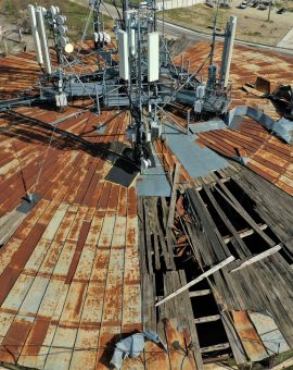
- Cell Towers & Communication Antennas: Providing detailed visual data for maintenance planning and repair.
4. Mapping, Surveying & Construction Progress
Drones are a game-changer for precise data collection and project management:
- Topographical Mapping: Generating highly accurate 2D maps and 3D models of terrain, used for urban planning, land development, and environmental studies.
- Construction Site Monitoring: Tracking progress, performing volumetric calculations (e.g., for aggregate piles), and creating digital twins of sites for better management and safety.
- Asset Management: Creating detailed visual records of equipment, buildings, and land for documentation and planning.
5. Search & Rescue and Public Safety
In emergencies, every second counts, and drones provide critical, real-time intelligence:
- Missing Persons: Covering vast areas quickly, especially in rugged terrain, and using thermal cameras to detect heat signatures day or night.
- Disaster Response: Assessing damage in flood zones, earthquake-hit areas, or after wildfires, guiding rescue efforts and providing situational awareness to first responders.
- Law Enforcement: Aiding in surveillance, crowd control, and providing aerial views of crime scenes or dangerous situations.
- Wildfire Monitoring: Tracking fire perimeters, identifying hotspots, and guiding firefighting efforts.
6. Environmental Monitoring & Wildlife Conservation
Drones are becoming invaluable tools for understanding and protecting our planet:
- Deforestation & Illegal Logging: Monitoring remote forest areas to detect illegal activities.
- Pollution Tracking: Identifying sources and spread of air and water pollution.
- Wildlife Tracking & Anti-Poaching: Observing animal populations without disturbance, and using thermal cameras to detect poachers in vast reserves.
- Coastal Erosion & Glacier Monitoring: Collecting data on environmental changes over time.
The Future is Above Us
While the applications listed above are already making a significant impact, the potential for drone camera technology is still unfolding. As AI integration, autonomous flight, and sensor technology continue to advance, we can expect even more sophisticated and specialized uses.
From safeguarding lives to optimizing industries and capturing unparalleled beauty, drone cameras are much more than just a passing trend. They are a fundamental shift in how we observe, interact with, and leverage the world around us – proving that sometimes, the best view really does come from above.